
We specialise in accurate and precise data collection using the latest UAV and survey instrumentation.

Use of UAV's for high level inspection of roofs, pylons and telecom masts is faster cheaper and safer than traditional methods.

Our drones are capabile of recording broadcast quality 4k video and super high resolution still imagery suitable for all manner of marketing purposes.

We are Surveying and Mapping Professionals who have adopted UAV technology into our business. We know its capibilities and limitations and all our work is carried out "in house". We utilize the latest technological survey solutions to provide the best possible service.
Whether its a building inspection, a topographic survey or a long range mapping project, we have the right people, experience and tools for the job.

Our CEO is a Fellow of RICS and is a Land Surveyor with 35 years experience of the industry. He has served on the RICS Geomatics board, NI board, Uk & Ireland WRB and International Governing Council. He is also an acknowledged expert in Boundary and Land Dispute matters.
We have a passion for surveying, technology and providing the best possible service.
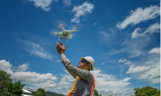
All our surveyors are fully qualified Geomatic Professionals and our UAV pilots are CAA and IAA licenced and insured.
We are Regulated by RICS and our CEO is a fellow of the RICS with over 35 years in the Land Surveying and Mapping industry.
We are based in Newry and Dublin and are available to answer any queries you might have. We enjoy providing innovative survey solutions.
We are commited to Life Long Learning and all our staff undertake relevant CPD programs to ensure that the are fully up to date with the latest regulation, technology and software.
As Surveying and Mapping Professionals we pride ourselves on going over and above to ensure a quality service and product.
We are proud of the fact that we have longstanding relationsips with our clients and that many new clients come by way of referrals and recommendations.